World news
fromwww.aljazeera.com
1 day agoSatellite images reveal Israel expanding Gaza military sites
Israel is constructing permanent military bases in Gaza while US-backed reconstruction efforts remain stalled.
Planet Labs PBC, known for taking pictures of Earth every single day, hit pause on the Middle East during an active war, creating a significant information gap in satellite imagery coverage of the region during this critical period.
The images, collected on Monday by the US spatial intelligence firm Vantor and obtained by Business Insider, show visible wreckage of at least two F-14 Tomcats on the apron at the 8th Tactical Air Base in Isfahan, a city in central Iran. The base is a hub for the Iranian Air Force's fleet of vintage F-14s.
The formation closely matches the outline of the Buffalo Valley Intermediate Field, an emergency triangular airfield built in the 1930s to 1940s along early aviation routes. In Nevada and other Western US deserts, triangular airfields were common in the 1930s and 1940s, serving early aviation needs such as mail routes and emergency landings.
The Book of Genesis describes Eden as a paradise watered by a single river that split into four: Pishon, Gihon, Tigris, and Euphrates. While the Tigris and Euphrates are well-known rivers in modern-day Iraq, the Pishon and Gihon have long been lost to history, until now. The dry riverbed, called Wadi al-Batin, stretches from the western highlands of Hejaz near Medina northeast to the northern Persian Gulf near Kuwait.
Satellite imagery of the Gaza war cemetery in al-Tuffah, a district of Gaza City, shows extensive earthworks in the southernmost corner of the graveyard. Bomb craters can be seen around the cemetery, but in this area the destruction appears to have been more systematic. Rows of gravestones have been removed, the topsoil has been churned up and a substantial earth berm can be seen running across the middle of the affected area.
Consider the Kamchatka Peninsula, a Russian territory that reaches into the Pacific Ocean north-east of Japan, which has been battling with record amounts of snow this winter. On January 16 alone, a small city on the peninsula's southern coast, called Petropavlovsk-Kamchatskiy, experienced a baffling five and a half feet of snow, effectively burying local residents and their cars completely. Some areas saw more than six and a half feet in just the first half of January.
From mapping and land ownership to avalanche forecasting, weather, and now high-resolution satellite imagery, onX has become a go-to platform for people who spend real time in the mountains. Today, we get into the nuts and bolts - how onX Backcountry actually works, how big their team is, how many people are using it, what problems they are trying to solve, and why their user experience stands out in an increasingly crowded space.
Satellites show one camp spanning 500,000 square metres near the city of al-Dabba, as tens of thousands seek refuge. Several displacement camps have emerged and are quickly filling with people who fled Sudan's devastated and largely emptied city of el-Fasher, which the paramilitary Rapid Support Forces (RSF) seized in an atrocity-ridden campaign in October. One camp has been established in the small town of Qarni, northwest of el-Fasher, according to satellite images reviewed by Al Jazeera's Sanad agency.
The Sudanese city of El Fasher resembles a massive crime scene, with large piles of bodies heaped throughout its streets as the paramilitary Rapid Support Forces (RSF) work to destroy evidence of the scale of their massacre. Six weeks after the RSF seized the city, corpses have been gathered together in scores of piles to await burial in mass graves or cremated in huge pits, analysis indicates.
Though they look still on the surface, millions of optical and radar satellite images collected from 2014-2022 reveal that the rate of each glacier's flow depends on the season and geographic location. In Arctic regions of Russia and Europe, for instance, glaciers typically reach top speeds during summer or early fall, while in Alaska, they accelerate the most during spring.
Africa's official maps are stuck in the past, often either outdated, incomplete-or both. But governments don't have the budgets to fix them, making it difficult to complete projects as complex as deciding where to put new solar plants to as simple as delivering a package. Now a new plan is underway to map the entire continent using satellite data and AI.
The fall of el-Fasher has resulted in the carpet-bombing of large swaths of the city by Sudan Armed Forces, an unknown number of civilian casualties caused by both sides, and almost 15 months of IPC-5 Famine conditions in areas caused by RSF's siege of the city, the HRL report said. The HRL determined this by reviewing satellite imagery and open source and remote sensing data from Monday.
Every year, regions of the world are hit by natural disasters such as hurricanes or floods. As a result of climate change, these phenomena have not only increased in number and severity, but it has also become more difficult to predict when they might occur. Although the areas most prone to these hazards try to take proactive measures, many sources of information are not timely enough or are of limited use.
"The sick and injured were executed in cold blood," the Sudanese Coordination of Resistance Committees, a nongovernmental organization, stated two days after the Rapid Support Forces (RSF) seized control of the city of el-Fasher, the capital of North Darfur, Sudan. According to the NGO, RSF fighters had either killed everyone or left them to die in the city's Al Saudi Hospital.
Russia's 2022 invasion of Ukraine was supposed to be a short campaign, but the larger country's swift victory anticipated by many analysts failed to materialize. Part of the reason for Ukraine's effective defense was Kyiv's early warning of the build-up of Russian forces on its border. U.S./allied intelligence warned Kyiv, but another non-government source tipped them off to the impending invasion: commercial imagery, especially Maxar's optical photos, publicly documented the build-up and the initial invasion, revealing the long convoy heading toward Kyiv on Feb. 27, 2022.
"Prior to my research, fewer than a dozen such traps were known across the entire pre-Hispanic Andes," Adrián Oyaneder, author of the research paper and an archaeologist at the University of Exeter in the UK, tells The Art Newspaper. "However, in parallel with a French research team, I was able to demonstrate that these structures are heavily concentrated in the Camarones Valley, where we documented 76 examples with strong indications of at least 100 more further to the south."
If you want the best view of Earth's landmarks, you'll need a ticket to space. Some of the world's most jaw-dropping sites - both natural and man-made - only reveal their true scale and beauty when captured from 250 miles overhead. The International Space Station has snapped images of some of these landmarks, such as the Great Barrier Reef, the Pyramids at Giza, and San Francisco's Golden Gate Bridge. Photos show how incredible landmarks look both from the ground and from way, way above.
But in Alaska, a new island has popped up in just four decades. The two-square-mile (five sq km) landmass, known as Prow Knob, was once entirely surrounded by the deep ice of the Alsek Glacier. But NASA has revealed that the small mountain has now been entirely surrounded by water, cutting it off from the mainland. An image taken by the Landsat 8 satellite in August shows that the mountain has now lost all contact with the Alsek Glacier.
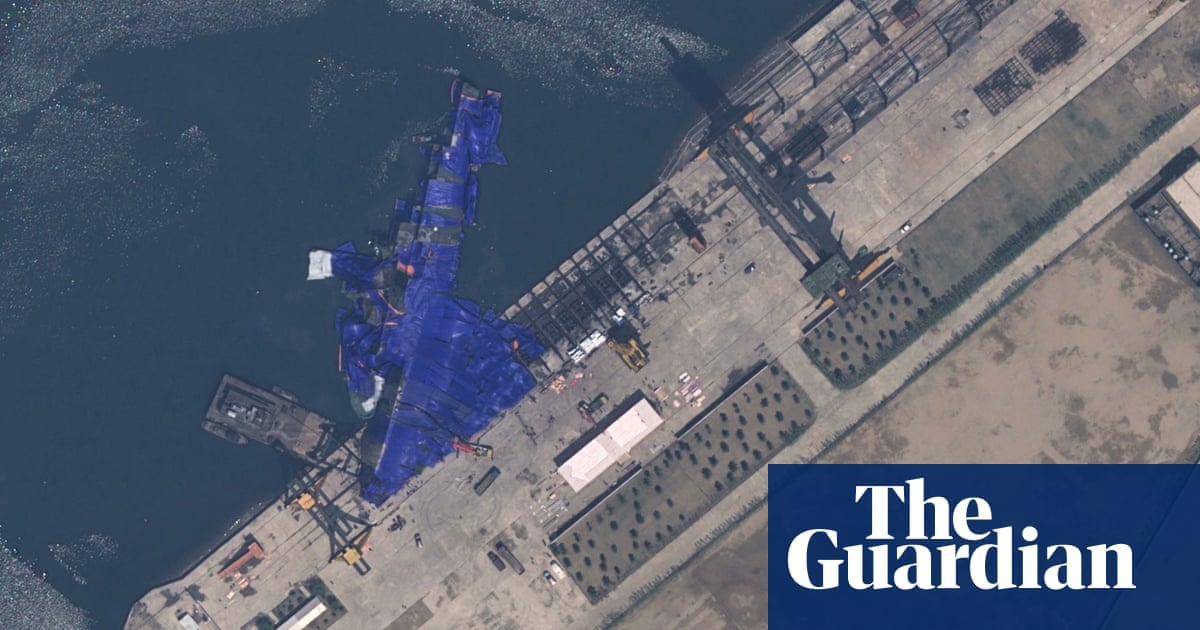
Satellite images reveal that Russia employed deceptive tactics at airbases, including using decoys and covering planes with tires to mislead Ukraine's targeting efforts.