"WeatherThis Colorado snow forecast favors a colder Sunday night through Monday storm, with the most snow on the northern and central mountains and only limited lift-served skiing still available. Arapahoe Basin is the only lift-served exception, with limited terrain for closing weekend through Sunday, while the other major Colorado resorts in this forecast area are closed for winter lift operations."
"Saturday afternoon and Sunday stay unsettled but mostly marginal for accumulating snow before colder air arrives. Scattered showers and thunderstorms favor brief graupel or wet snow on the highest peaks, with snow levels generally above 9,500-11,500 feet during the warmer part of the weekend. The individual models are converging on increasing Sunday night precipitation and a Monday temperature drop, while wind guidance also lines up on a gusty southwest-to-west period ahead of the trough, strongest across the southern and central mountains where gusts could reach 40-50 mph."
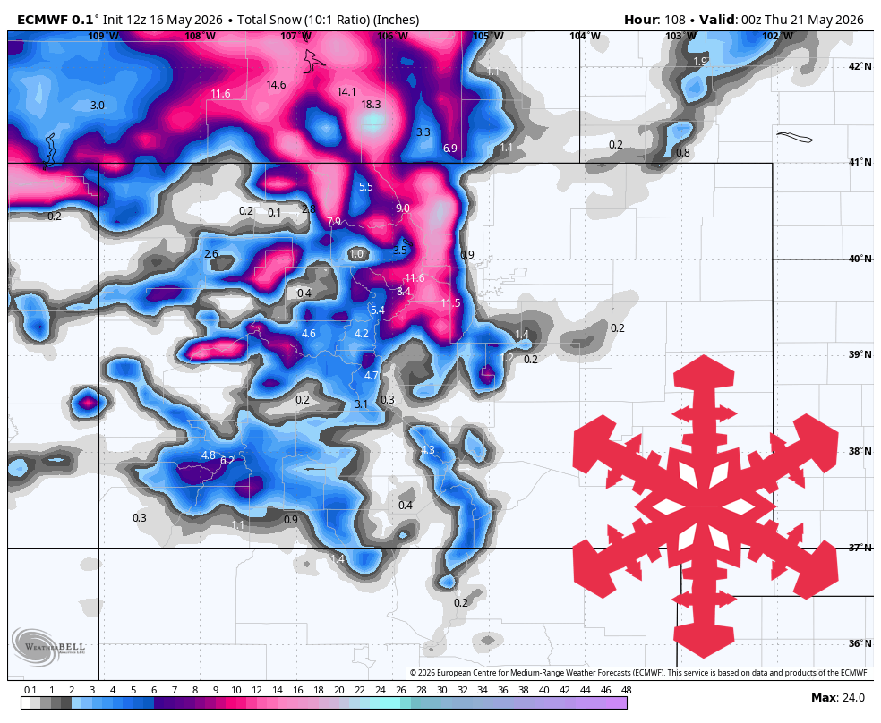
"Sunday night through Monday is the main storm period, and the model spread is small enough to use specific snowfall totals through Wednesday evening. Snow levels fall from roughly 10,000-11,000 feet early to around 6,500-8,500 feet by Monday, favoring all-snow at upper-mountain elevations and wet, dense snow at lower elevations when precipitation is falling. Snow quality looks dense to fair at first, with SLRs mostly 8:1-12:1, then briefly improving toward 12:1-15:1 in colder Monday night showers."
A colder Sunday night through Monday storm is expected to bring the most snow to northern and central Colorado mountains, while most lift-served resorts are closed for winter operations. Arapahoe Basin is the only lift-served exception, with limited terrain available through Sunday. Saturday afternoon and Sunday remain unsettled but mostly marginal for accumulating snow, with scattered showers and thunderstorms producing brief graupel or wet snow on the highest peaks. Sunday night precipitation increases and Monday temperatures drop, with gusty southwest-to-west winds strongest across southern and central mountains, reaching 40–50 mph. Snow levels fall from about 10,000–11,500 feet early to roughly 6,500–8,500 feet by Monday, supporting all-snow at upper elevations and wet, dense snow lower down.
Read at SnowBrains
Unable to calculate read time
Collection
[
|
...
]