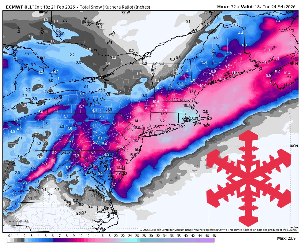
"A strong coastal storm Sunday night into Monday brings a sharp snowfall gradient across New England while lake effect and a clipper keep snow going in Michigan's Keweenaw. The bullseye favors southern New Hampshire and western Maine, with amounts dropping off quickly as you head north into Vermont and Quebec. Temperatures stay cold enough for snow at all elevations in the near term, and wind will be a big part of the story on Monday, especially in exposed terrain."
"Sunday night through Tuesday, expect about 3″-8″ in the White Mountains and Maine high terrain, 4″-5″ in southern Vermont, and 1″-3″ along the northern Vermont spine, with little to no accumulation pushing into Quebec. The ECMWF, the AIFS, and the GFS have moved closer on the storm track, and confidence has increased in a meaningful hit for southern New Hampshire and parts of Maine."
"In the Upper Peninsula, lake effect Sunday into Monday plus a Tuesday clipper add up to roughly 7″-9″ at Mt. Bohemia through Tuesday. The models line up well on steady snow potential in the Keweenaw in this window, with the most persistent periods tied to north winds off Lake Superior. Snow quality looks strong, with SLRs commonly in the mid-teens and occasionally near 20:1, so turns should stay light and dry when the wind backs off."
A strong coastal storm Sunday night into Monday will produce a sharp snowfall gradient across New England, favoring southern New Hampshire and western Maine while totals fall quickly into Vermont and Quebec. Forecast amounts include 3–8 inches in the White Mountains and Maine high terrain, 4–5 inches in southern Vermont, and 1–3 inches along northern Vermont's spine. ECMWF, AIFS, and GFS convergence raises confidence for southern New Hampshire and parts of Maine while ICON and GDPS keep a sharp northern cutoff. Snow-to-liquid ratios near 12–18:1 support good light snow. Monday will feature strong winds and blowing snow at higher elevations. In Michigan's Keweenaw, lake-effect snow plus a Tuesday clipper should yield roughly 7–9 inches at Mt. Bohemia with SLRs commonly in the mid-teens to near 20:1. Colder, breezy conditions follow Tuesday with additional, timing-uncertain snow chances later in the week into early March.
Read at SnowBrains
Unable to calculate read time
Collection
[
|
...
]