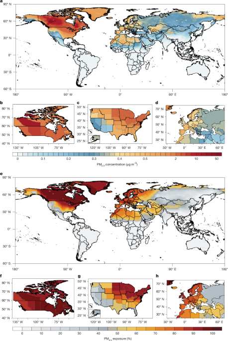
Multiple datasets and models were combined to estimate contributions of Canadian wildfires to global PM2.5 exposure and health impacts for 2023, with 2021 and 2017 analyzed for comparison. GEOS-Chem chemical transport simulations at 2° × 2.5° used three near-real-time global fire emission inventories (GFEDv4.1s, QFEDv2.5r1, GFASv1.2) and a zero-out approach to simulate global daily PM2.5 and wildfire fractional contributions. A machine-learning PM2.5 retrieval model integrated ground monitoring, satellite retrievals, reanalysis data, and GEOS-Chem outputs to estimate daily PM2.5 at 0.1° × 0.1°. Retrieved PM2.5 totals were multiplied by simulated fractional contributions to derive wildfire-attributable PM2.5, and the three inventories were evaluated for performance.
"We first used the GEOS-Chem chemical transport model at a spatial resolution of 2° × 2.5° and 3 near-real-time global fire emission inventories, that is, the Global Fire Emissions Database version 4 with small fires (GFEDv4.1s), the Quick Fire Emissions Dataset version 2.5 (QFEDv2.5r1) and the Global Fire Assimilation System version 1.2 (GFASv1.2), to simulate the global daily PM 2.5 concentrations and the fractional shares in total PM 2.5 concentrations contributed by wildfire emissions using a zero-out approach."
"Second, to improve the spatial resolution and accuracy of the global daily PM 2.5 estimation, we developed a machine-learning-based PM 2.5 retrieval model that combines data from multiple sources, including ground-monitoring measurements, satellite retrievals, reanalysis data and GEOS-Chem simulations, to estimate the global daily PM 2.5 concentrations at a spatial resolution of 0.1° × 0.1°. The PM 2.5 retrieval model was trained using GEOS-Chem simulations with the GFED, the QFED and the GFAS as a priori fire emissions, respectively, and three sets of global daily PM 2.5 estimates were derived. Then the retrieved total PM 2.5 concentrations based on the GFED, the QFED and the GFAS were multiplied by previously simulated fractional contributions with corresponding fire emissions, to obtain the PM 2.5 exposure attributable to wildfires."
Read at Nature
Unable to calculate read time
Collection
[
|
...
]