"Dry, mild weather holds through Friday, then a weekend storm cycle runs from Friday night into Tuesday with a warm start and a colder finish. Snow levels start high on Saturday, so upper mountain terrain and northern locations do the best with wet snow while some lower slopes mix with rain. Colder air arrives Sunday night into Tuesday, dropping snow levels toward 3,000 feet and improving snow quality as SLRs climb into the 10-13:1 range."
"Friday night through Sunday is a warm start with higher snow levels and dense snow, especially in Oregon and at lower-elevation bases in Washington and British Columbia. Snow levels hover near 4,300 to 4,600 feet around Whistler early, climb into the 6,000 to 7,200 feet range in the Oregon Cascades by Saturday night, and sit closer to 3,000 to 5,300 feet for much of Washington, with Mt Baker on the cooler end."
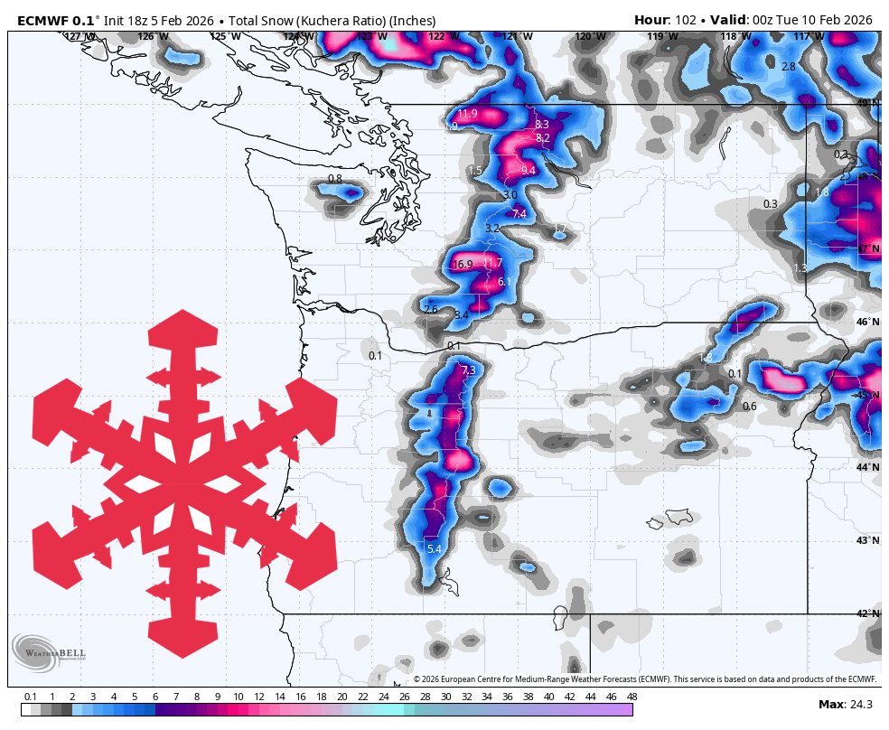
"Sunday night through Tuesday is the colder phase, and it delivers the most reliable combination of lower snow levels and better snow quality. Snow levels fall toward 3,000 to 4,000 feet for much of the Cascades, with the North Cascades and Whistler often nearer 2,300 to 3,000 feet, so more of the mountain stays on snow instead of rain. SLRs trend into the 10-13:1 range, which supports moderate, more skiable snow once temperatures sett"
Dry, mild weather persists through Friday before a weekend storm cycle runs from Friday night into Tuesday with a warm start and colder finish. Snow levels rise Saturday, favoring upper-mountain and northern terrain with wet, dense snow while some lower slopes mix with rain. Whistler early hovers near 4,300–4,600 ft, Oregon Cascades climb into 6,000–7,200 ft, and much of Washington sits near 3,000–5,300 ft. Early SLRs are commonly 5–8:1. Ridgetop winds strengthen in Oregon with gusts up to ~70 mph. Sunday night into Tuesday brings colder air, falling snow levels (often 2,300–4,000 ft) and SLRs near 10–13:1, improving skiability. Mid to late next week remains unsettled with additional reload chances and a broader mid-February pattern leaning cool and wet for Washington and Oregon.
Read at SnowBrains
Unable to calculate read time
Collection
[
|
...
]