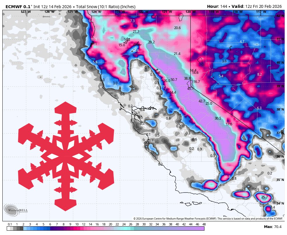
"Two waves drive the bulk of the snow, with a relatively higher snow level and denser snow early, followed by a colder surge that improves powder quality and brings the strongest winds. Expect long stretches of snowfall for the Sierra with only brief lulls, plus periods of wind-driven, low-visibility skiing on upper mountain. Southern California gets meaningful mountain snow as well, but snow levels are a bigger deal there and the best accumulation favors higher terrain."
"Sunday night through Monday evening kicks off the first wave, with snow levels starting relatively high and winds ramping quickly. All models are all locked onto a widespread start overnight Sunday, with the snow turning heavy on Monday even though the exact start time varies by several hours. In the Sierra, snow levels generally run about 4,500 to 6,000 feet early, which keeps most bases cold enough for snow but can make the first round denser near the lowest elevations."
"In Southern California, snow levels start around 6,500 to 7,000 feet Monday, and snow ratios often sit closer to 5 to 10:1 early, so the upper mountain is the clear winner while lower elevations can lean wetter and heavier. Tuesday afternoon through early Wednesday brings the colder Sierra surge, and Wednesday into Thursday looks like the best all-snow window for Southern California. For the Sierra, guidance converges on snow levels dropping hard as the colder wave arrives, commonly falling into the 1,500 to 2,500 foot range by Wednesday, which locks in snow from base to summit a"
A major storm will produce widespread heavy snowfall across the Sierra, with totals generally 25–100+ inches and Mount Baldy around 20–35 inches. Two waves will drive accumulation: an initial warmer, denser round with higher snow levels and strong winds, then a colder surge that lowers snow levels, improves powder quality, and brings the strongest winds. Early Sierra snow ratios near 9–12:1 and Southern California ratios closer to 5–10:1 will make the first round heavier. Snow levels fall from several thousand feet to roughly 1,500–2,500 feet by midweek. Colder-than-normal conditions follow, favoring additional northern snow.
Read at SnowBrains
Unable to calculate read time
Collection
[
|
...
]