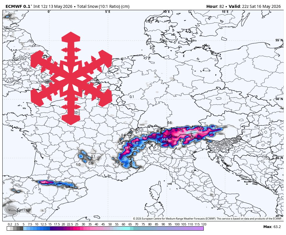
"The strongest totals favor higher Alpine terrain from Austria into Switzerland and parts of the western Alps, while lower-elevation and eastern fringe areas see lighter accumulations. Confidence is highest from Wednesday night, May 13, through early Sunday, May 17, when the individual models agree well on the timing, snow levels, and generally modest wind impacts, though they still differ on exact intensity."
"The late-week storm arrives in two main waves, first building late Wednesday night into Thursday and then reloading Friday into Saturday. The individual models converge on that broad timing, with the steadiest snow focused from Thursday morning through Saturday evening before tapering around early Sunday. Snow levels should mostly run near 1,200-1,700 meters on Thursday, then trend closer to 1,000-1,600 meters Friday and Saturday, keeping the better snow quality in the upper-mountain terrain."
"Published totals for this period support a broad 20-50 cm outcome for many favored high Alpine areas, with Sölden, Samnaun, Chamonix, and the Jungfrau region among the stronger performers. Snow quality looks mostly moderate for May, with some dense periods mixed in during the warmer or lower-elevation hours. SLRs generally sit in the 10-14 range during the main storm, with pockets closer to 7-10 during denser bursts and occasional 14-15 ratios in colder upper-elevation snow."
"The individual models are fairly aligned on wind being a secondary issue rather than the main story, with many exposed areas seeing breezes and periodic gusts around 20-35 km/h. Where late-season lifts are still running, Thursday through Saturday should offer the best chance for fresh upper-mountain turns, especially after the Friday-Saturday reload. Sunday turns quieter, then the models diverge quickly on whether a weak Monday-Tuesday disturbance can"
A cold, active late-week pattern brings the strongest mountain snow from Wednesday night through Saturday night across the EU Alps. The highest totals favor higher Alpine terrain from Austria into Switzerland and parts of the western Alps, while lower elevations and eastern fringe areas receive lighter accumulations. The storm arrives in two waves, building late Wednesday night into Thursday and reloading Friday into Saturday. Snow is steadiest from Thursday morning through Saturday evening, tapering around early Sunday. Snow levels mostly run near 1,200–1,700 meters on Thursday, then trend closer to 1,000–1,600 meters Friday and Saturday, improving snow quality in upper terrain. Broad totals of 20–50 cm are supported for many favored high areas, with Sölden, Samnaun, Chamonix, and the Jungfrau region among stronger performers. Snow quality is generally moderate for May, with dense periods during warmer or lower-elevation hours. SLRs typically range 10–14, with pockets near 7–10 and occasional 14–15 in colder upper snow. Winds are secondary, with breezes and gusts around 20–35 km/h, and the best fresh turns are expected Thursday through Saturday, especially after the Friday–Saturday reload.
Read at SnowBrains
Unable to calculate read time
Collection
[
|
...
]