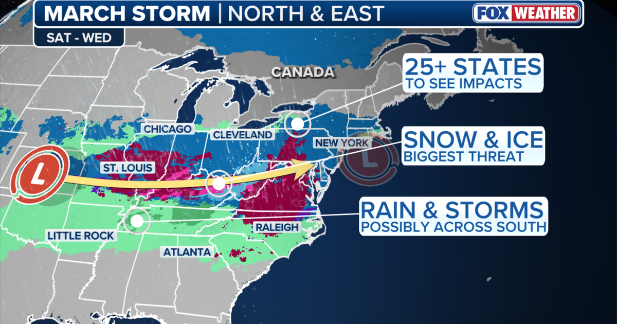
The FOX Forecast Center is monitoring a weather system developing in the Midwest that could move into the Northeast early next week. Long-range models indicate potential accumulating snow from the Ohio Valley through the I-95 corridor, including New York City, northern New Jersey, and Connecticut. Several inches of snowfall are possible if sufficient cold air remains and the storm tracks far enough north. The eventual storm track and cold air availability will be critical factors determining snow totals. A favorable path could produce measurable accumulation, while a southern shift or warmer track could reduce totals or introduce mixed precipitation. Forecast confidence remains low at this range, with timing and exact amounts likely to change as models refine predictions over the coming days.
"The FOX Forecast Center is monitoring a developing system that could track from the Midwest into the Northeast early next week. Long-range models show the possibility of accumulating snow stretching from the Ohio Valley into parts of the I-95 corridor, including New York City, northern New Jersey and portions of Connecticut."
"Some model scenarios indicate several inches of snowfall are possible if enough cold air remains in place and the storm tracks far enough north. The eventual track of the storm and the availability of cold air will be critical."
"If the system strengthens and moves along a favorable path, portions of the Tri-State area could see measurable snow accumulation. A shift south could limit totals, while a warmer track could introduce mixed precipitation instead. At this range, meteorologists caution that forecast confidence is still low."
#winter-weather-forecast #northeast-snow-potential #tri-state-area-storm #early-march-weather-system
Read at FOX 5 New York
Unable to calculate read time
Collection
[
|
...
]