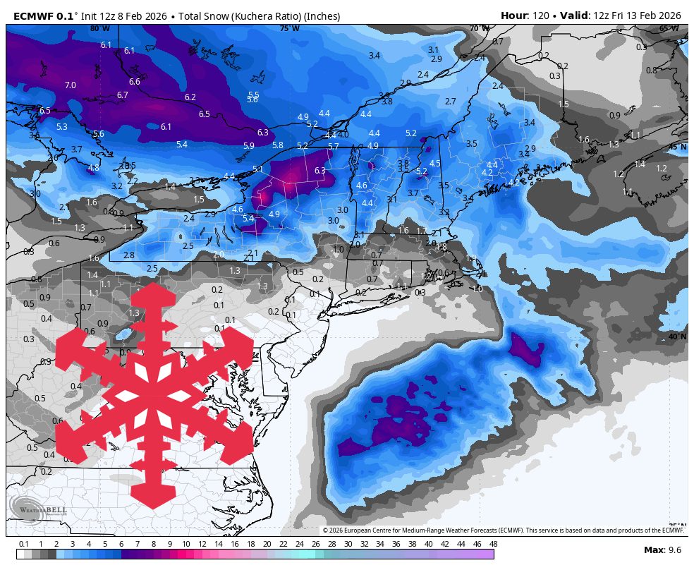
"Arctic cold holds on through Monday, then a Tue night (02/10) - Thu (02/12) clipper delivers the best snow of the week, topping out around 4″-9″ in the northern Greens and the White Mountains. Snow levels stay pinned near 0 feet during the midweek wave and SLRs mostly run 14-19:1, so snow quality should be light and fluffy once the snow starts Tuesday night."
"Wind chills dip to roughly -15°F to -30°F near sunrise Monday, so plan on true midwinter gear and seek sheltered terrain early week. Snow spreads in Tuesday afternoon and evening, with the steadiest push through Tuesday night into early Wednesday and a more showery, terrain-driven finish into Thursday. Snow levels stay at 0 feet and temperatures hold in the teens to low 20s, keeping this all snow from base to summit."
"Ridgetops turn breezy, with gusts commonly 30-50 mph and a few exposed summits possibly touching 60 mph as flow swings from southwest to northwest; the ECMWF is generally the low side on totals, while the GFS and the GDPS are running higher in the Whites and northern Vermont. Snow showers fade to lighter, wind-driven upslope on Thu (02/12), then late week trends drier with a noticeable warming trend into the weekend."
Bitter Arctic cold persists through Monday with wind chills near -15°F to -30°F at sunrise, requiring true midwinter gear and sheltered travel early week. A fast-moving clipper arrives Tuesday night into Thursday, producing the best snowfall of the week with light, fluffy snow where SLRs run 14–19:1 and snow levels remain near 0 feet. Northern Greens and the White Mountains have the highest totals around 4–9″, western Maine 2–5″, and Quebec City area 1–2″. Ridgetops become breezy with gusts commonly 30–50 mph. Late week turns milder and drier, with lower-confidence systems possible next weekend.
Read at SnowBrains
Unable to calculate read time
Collection
[
|
...
]