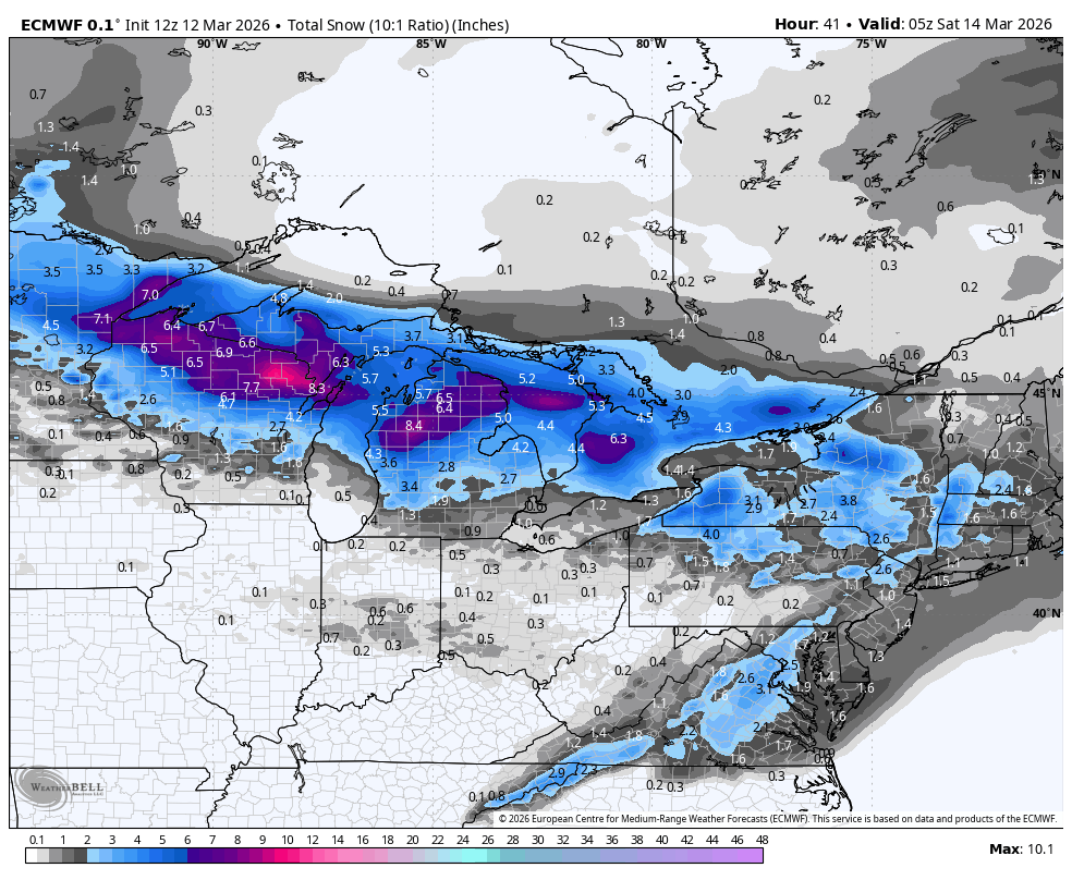
"Confidence is highest from Thursday night through Friday night, when guidance is tightly clustered on a fast clipper crossing the Upper Midwest with snow spreading west to east and peak rates overnight. Lutsen, Giants Ridge, Whitecap, Mount Bohemia, and the northern Lower Michigan hills should land near 4″-9″, while Granite Peak looks more borderline with wetter 3″-4″ totals and snow levels briefly rising toward 1,800 feet."
"Snow quality will not be blower. Ratios mostly sit in the 8:1 to 14:1 range at the colder northern resorts, which means dense to moderate snow, while Granite Peak is even heavier around 6:1 to 8:1. Winds are part of the story everywhere, with sustained speeds often 20-35 mph and gusts frequently 45-70 mph, so exposed chairs and upper-mountain terrain will feel rough even where snowfall is solid."
"Friday night and much of Saturday offer the brief reset, but guidance then locks onto another storm from late Saturday through Monday with much bigger stakes and noticeably more spread. Agreement is good on a broad swath of snow and another round of strong wind, but guidance still diverges on the exact north edge of the heavy band, how long it lingers Sunday night, and whether the southern fringe near Cascade mixes at times."
A fast-moving clipper system crosses the Upper Midwest Thursday night through Friday, delivering dense to moderate snow with peak rates overnight. Northern resorts including Lutsen, Whitecap, and Mount Bohemia expect 4-9 inches, while southern areas like Cascade and Afton remain mostly wet. Snow ratios range from 8:1 to 14:1 at colder northern locations, producing heavy snow despite moderate accumulations. Sustained winds of 20-35 mph with gusts reaching 45-70 mph create rough conditions on exposed terrain. After a quieter Saturday, a broader late-weekend storm system develops with higher confidence in significant snow production, particularly across Wisconsin and northern Lower Michigan, though exact placement and southern extent remain uncertain.
#midwest-ski-weather #winter-storm-forecast #snow-accumulation #wind-conditions #upper-midwest-resorts
Read at SnowBrains
Unable to calculate read time
Collection
[
|
...
]