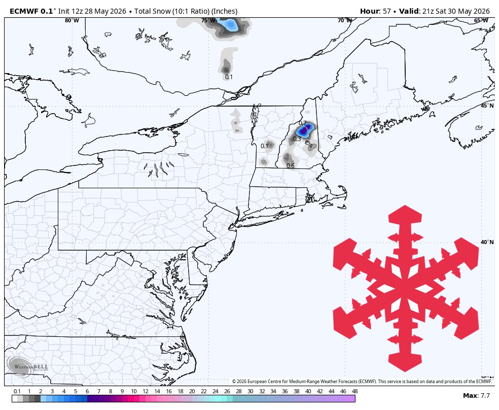
A brief cold system is expected Friday night into Saturday, followed by a cool, showery period and a warmer, lower-precipitation pattern next week. Resort skiing is closed, so the main value is assessing high-elevation backcountry conditions. The clearest accumulation signal is in the White Mountains, where higher terrain near Wildcat and Cannon may receive 2–7 inches of dense, wet snow, while much of Vermont, western Maine, and Quebec see little or none. Thursday into Friday stays cool and unsettled with clouds and passing rain showers. Models agree on timing and a windy, colder mountain profile, but differ on intensity and snow level overlap west of the White Mountains. Snow levels lower to about 1,500–3,000 feet where precipitation is heaviest, with gusts on exposed ridges reaching 35–55 mph and snow-to-liquid ratios mostly 4–8:1. Confidence is highest from Friday evening through Saturday afternoon, with rapid settling and melting outside the highest terrain.
"The Northeast snow forecast is focused on one short, cold late-spring system Friday night into Saturday, followed by a cool, showery stretch and then a warmer, lower-precipitation pattern next week. All Northeast resorts are closed for winter lift-served skiing, so the practical value is for high-elevation backcountry assessment rather than resort powder chasing. The best accumulation signal is in the White Mountains, where the highest terrain around Wildcat and Cannon can pick up 2-7 in of dense, wet snow, while most Vermont, western Maine, and Quebec areas see little or none."
"Thursday into Friday stays cool and unsettled under northwest flow, with clouds, passing rain showers, and temperatures mainly in the 30s to 50s °F on the mountains. The individual models converge on a sharper system arriving Friday evening and peaking overnight into Saturday morning, with broad agreement on a windy, colder mountain profile, but they diverge on intensity and on how much low snow level air overlaps precipitation west of the White Mountains."
"Snow levels should lower into roughly 1,500-3,000 feet where precipitation is heaviest, low enough for high-elevation snow but marginal for lower slopes. Wind gusts on exposed ridges can reach 35-55 mph, and the snow should be wet and dense with SLRs mostly 4-8:1. Confidence is strongest from Friday evening, May 29, through Saturday afternoon, May 30, when the models agree on timing but not on the western edge of the accumulating snow."
"The White Mountains have the clearest snowfall signal, with Wildcat favored for 5-7 in and Cannon Mountain for 2-3 in; Killington and Sugarloaf are closer to 1 in, and most other resort elevations are near 0 in. Because this falls onto a late-May surface and all resorts are closed, expect rapid settling and melting outside the highest shaded terrain. Sunday through Wednesday remains cool for the season with periodic showers, but the individual models increasingly diverge on the placement and streng"
Read at SnowBrains
Unable to calculate read time
Collection
[
|
...
]