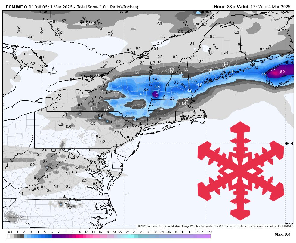
"Sunday and Monday stay sharply cold with only light nuisance snow early, followed by a better but still modest snowfall window Tuesday afternoon through early Wednesday. After that, confidence drops as a broader Thursday night through weekend precipitation cycle arrives with bigger spread on snow versus rain at different elevations."
"Guidance is converging best from now through early Wednesday, with most resorts landing around 0″-2″ and the best shot at 2″-3″ centered on Killington and nearby higher terrain during Tuesday night's wave. Snow levels are also clustered low during snowfall, mostly from valley floors up to around 1,000 feet, which supports snow at ski elevations rather than prolonged mixing."
"From Thursday night through the weekend, models converge on timing for a broader precipitation round but diverge on intensity and snow levels, supporting a conservative snow expectation near 3″-8″ for many northern New England mountains with a colder upside closer to 8″-15″ in favored higher terrain."
A cold, dry pattern dominates through early Wednesday with light snow Tuesday afternoon through early Wednesday morning, primarily affecting higher terrain around Killington with 2-3 inches possible. Snow levels remain low, supporting accumulation at ski elevations rather than rain mixing. Temperatures plunge to -5°F to 15°F in higher terrain before moderating into the 20s and low 30s Tuesday night. Wind gusts reach 25-40 mph with occasional stronger bursts. A broader precipitation system arrives Thursday night through the weekend with greater uncertainty regarding snow versus rain at different elevations. Northern New England mountains could receive 3-8 inches conservatively, with potential for 8-15 inches in favored higher terrain if colder conditions prevail. Sustained winds of 25-40 mph with frequent 50+ mph gusts are expected.
#northeast-weather-forecast #winter-storm-prediction #snow-accumulation #temperature-trends #wind-impacts
Read at SnowBrains
Unable to calculate read time
Collection
[
|
...
]